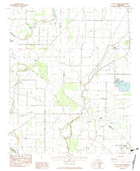
1983 Map of Curtis Station
USGS Topo · Published 1983About this map
The Old Indian Treaty Boundary cuts diagonally through this landscape, dividing a network of drainage ditches and bayous along the Quitman and Panola county line. This 1983 survey shows a heavily managed agricultural terrain characterized by spoil banks and levees, where the complex hydrology includes Bobo Bayou, Ash Log Bayou, and Fourmile Bayou. Small rural nodes like Curtis Station and Locke Station appear alongside numerous community churches, such as Pilgrims Rest Ch and Goodwill Ch, which serve as vital landmarks for genealogists tracing family histories in the Mississippi Delta.
Find a feature on this map
29 named features on this map. Tap any name to fly to it.
Don’t see what you’re looking for? This feature index may not catch every label — zoom into the map to look around manually.
Map Details
Editions of this 1983 Curtis Station Map
This is the sole edition of this map. No revisions or reprints were ever made.
Other maps of this area

1932 · Sledge
USGS Topo · 1:48,000

1932 · Tutwiler
USGS Topo · 1:48,000

1932 · Marks
USGS Topo · 1:48,000

1935 · Crowder
USGS Topo · 1:62,500

1935 · Marks
USGS Topo · 1:62,500

1935 · Tutwiler
USGS Topo · 1:62,500

1935 · Sledge
USGS Topo · 1:62,500

1939 · Sledge
USGS Topo · 1:62,500

1939 · Crowder
USGS Topo · 1:62,500

1939 · Tutwiler
USGS Topo · 1:62,500