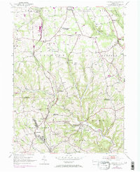
1953 Map of Curtisville
USGS Topo · Published 1970About this map
The Bessemer and Lake Erie railroad cuts a vital corridor through this landscape along the border of Allegheny and Butler Counties, connecting small mining and agricultural hamlets. Settlements like Culmerville and Curtisville are densely mapped, showing the residential patterns of a region shaped by industry and the nearby rails. The presence of the Carnegie Institute of Technology (Research Center) north of Clinton indicates the area's mid-century role in institutional research, while numerous labeled mines along the hillsides of Coal Hollow and Bull Creek reveal the literal foundations of the local economy. Genealogists will find significant detail in the distribution of rural landmarks, from the Oak Grove Cem to several local congregations including St Paul Ch and Westminster Ch, which served the scattered communities of Lardintown and Sarverville.
Find a feature on this map
47 named features on this map. Tap any name to fly to it.
Don’t see what you’re looking for? This feature index may not catch every label — zoom into the map to look around manually.
Map Details
Editions of this 1953 Curtisville Map
Other maps of this area

1900 · Kittanning
USGS Topo · 1:62,500

1902 · Kittanning
USGS Topo · 1:62,500

1907 · Freeport
USGS Topo · 1:62,500

1908 · New Kensington
USGS Topo · 1:62,500

1909 · Freeport
USGS Topo · 1:62,500

1909 · Butler
USGS Topo · 1:62,500

1910 · New Kensington
USGS Topo · 1:62,500

1911 · Butler
USGS Topo · 1:62,500

1950 · Valencia
USGS Topo · 1:24,000

1953 · Pittsburgh
USGS Topo · 1:250,000
Featured Places
- Clinton Township, PA
- Red Hot, West Deer Township
- Buffalo Township, PA
- Winfield Township, PA
- Jefferson Township, PA