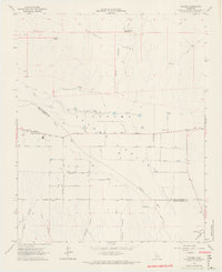
1964 Map of Cuyama
USGS Topo · Published 1965About this map
Oil exploration and ranching history converge in the Cuyama Valley on this mid-century survey, which details a landscape defined by industrial development and dry-land water management. The settlement of Cuyama sits at the western edge of the valley floor, surrounded by a dense network of wells that reflect the post-war petroleum boom. These numerous extraction points are concentrated north of the Cuyama River, particularly across the area noted as the property of the (Heirs of Cesario Lataillade), a label that points back to the region's Mexican land grant origins.
Find a feature on this map
26 named features on this map. Tap any name to fly to it.
Don’t see what you’re looking for? This feature index may not catch every label — zoom into the map to look around manually.
Map Details
Editions of this 1964 Cuyama Map
3 editions found
Other maps of this area

1902 · Santa Ynez
USGS Topo · 1:125,000

1903 · Mt. Pinos
USGS Topo · 1:125,000

1905 · Santa Ynez
USGS Topo · 1:125,000

1910 · Buena Vista Lake
USGS Topo · 1:125,000

1912 · McKittrick
USGS Topo · 1:125,000

1912 · Buena Vista Lake
USGS Topo · 1:125,000

1942 · Ballinger Canyon
USGS Topo · 1:24,000

1942 · East of Cuyama Ranch
USGS Topo · 1:24,000

1943 · Maricopa
USGS Topo · 1:31,680

1943 · Cuyama Ranch
USGS Topo · 1:31,680