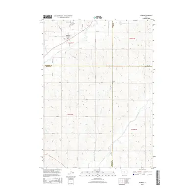
2015 Map of Danbury
USGS Topo · Published 2015About this map
Danbury serves as the primary hub in this northwestern Iowa landscape, situated where the Maple River valley meets a network of county roads. The town's local history is anchored by a cluster of community sites including Saint Marys Cem, Saint Patricks Cem, and the Danbury Cem. The geography is defined by a transition between several major drainage systems, with the Maple River flowing through the northwest and the Soldier River cutting across the southeast, joined by numerous tributaries like Rush Cr and Heisler Cr.
Find a feature on this map
32 named features on this map. Tap any name to fly to it.
Don’t see what you’re looking for? This feature index may not catch every label — zoom into the map to look around manually.
Map Details
Editions of this 2015 Danbury Map
This is the sole edition of this map. No revisions or reprints were ever made.
Other maps of this area

1954 · Fort Dodge
USGS Topo · 1:250,000

1957 · Fort Dodge
USGS Topo · 1:250,000

1958 · Fort Dodge
USGS Topo · 1:250,000

1967 · Battle Creek
USGS Topo · 1:24,000

1969 · Danbury
USGS Topo · 1:24,000

1969 · Holstein SW
USGS Topo · 1:24,000

1969 · Mapleton
USGS Topo · 1:24,000
1969 · Correctionville SE
USGS Topo · 1:24,000
1971 · Mapleton SE
USGS Topo · 1:24,000

1971 · Ricketts
USGS Topo · 1:24,000