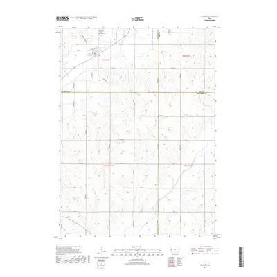
2018 Map of Danbury
USGS Topo · Published 2018About this map
Danbury serves as the primary hub of this Western Iowa landscape, situated along the Maple River where local routes like Danbury Blacktop and Co Hwy L37 converge. The topography is defined by a dense network of watercourses, including Reynolds Cr, Rush Cr, and Skunk Cr, which carve through the agricultural sections and township lines. Genealogy and local history are anchored by several notable sites, such as Saint Patricks Cem and the Danbury Cem located just north of the town center, while the Hartleben Cem provides a point of interest further south near Rush Cr. The southern portion of the map transitions into the Soldier River drainage, illustrating the complex watershed divide that characterizes the borderlands of Woodbury, Monona, and Crawford counties.
Find a feature on this map
57 named features on this map. Tap any name to fly to it.
Don’t see what you’re looking for? This feature index may not catch every label — zoom into the map to look around manually.
Map Details
Editions of this 2018 Danbury Map
This is the sole edition of this map. No revisions or reprints were ever made.
Other maps of this area

1954 · Fort Dodge
USGS Topo · 1:250,000

1957 · Fort Dodge
USGS Topo · 1:250,000

1958 · Fort Dodge
USGS Topo · 1:250,000

1967 · Battle Creek
USGS Topo · 1:24,000

1969 · Danbury
USGS Topo · 1:24,000

1969 · Holstein SW
USGS Topo · 1:24,000

1969 · Mapleton
USGS Topo · 1:24,000
1969 · Correctionville SE
USGS Topo · 1:24,000
1971 · Mapleton SE
USGS Topo · 1:24,000

1971 · Ricketts
USGS Topo · 1:24,000