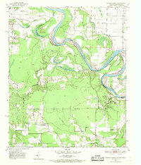
1951 Map of Daniels Chapel
USGS Topo · Published 1969About this map
The Red River creates a meandering natural boundary at the meeting point of Texas and Arkansas on this mid-century survey. The landscape is defined by the river's shifting path, which has carved out notable features like Paul Moore Island and Gano Island, while the floodplain is dotted with backwaters including Hurricane Bend Lake and Brushy Lake. On the Texas side in Bowie County, small rural communities such as Daniels Chapel, Almont, and Woodstock anchor the agricultural uplands. Evidence of local community life is visible in the distribution of country churches like Macedonia Ch and the Spring Branch Cem. Historical river crossings and landforms are well-documented, with Lewis Ferry providing transit across the water near the prominent Spanish Bluff. This map serves as a detailed record of the border region's river-and-rail era before significant modern development altered the drainage patterns of the bottomlands.
Find a feature on this map
39 named features on this map. Tap any name to fly to it.
Don’t see what you’re looking for? This feature index may not catch every label — zoom into the map to look around manually.
Map Details
Editions of this 1951 Daniels Chapel Map
4 editions found

Other maps of this area

1909 · New Boston
USGS Topo · 1:62,500

1930 · Bassett
USGS Topo · 1:62,500

1950 · Redbank
USGS Topo · 1:24,000

1950 · Tom
USGS Topo · 1:24,000

1950 · De Kalb
USGS Topo · 1:24,000

1951 · De Kalb
USGS Topo · 1:24,000

1951 · Tom
USGS Topo · 1:24,000

1951 · Redbank
USGS Topo · 1:24,000

1951 · Arden
USGS Topo · 1:24,000

1951 · Foreman
USGS Topo · 1:24,000