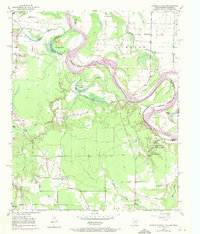
1951 Map of Daniels Chapel
USGS Topo · Published 1971About this map
The Red River meanders across the borderlands of Texas and Arkansas, defining a landscape of shifting channels and low-lying bottomlands. The intricate drainage network includes oxbow features like Hurricane Bend Lake and Brushy Lake, alongside Gano Island and Paul Moore Island. These waterways created a unique geographic environment where boundaries were often labeled as an Indefinite Boundary or Approximate Boundary due to the river's historical movement.
Find a feature on this map
37 named features on this map. Tap any name to fly to it.
Don’t see what you’re looking for? This feature index may not catch every label — zoom into the map to look around manually.
Map Details
Editions of this 1951 Daniels Chapel Map
4 editions found

Other maps of this area

1909 · New Boston
USGS Topo · 1:62,500

1930 · Bassett
USGS Topo · 1:62,500

1950 · Redbank
USGS Topo · 1:24,000

1950 · Tom
USGS Topo · 1:24,000

1950 · De Kalb
USGS Topo · 1:24,000

1951 · De Kalb
USGS Topo · 1:24,000

1951 · Tom
USGS Topo · 1:24,000

1951 · Redbank
USGS Topo · 1:24,000

1951 · Arden
USGS Topo · 1:24,000

1951 · Foreman
USGS Topo · 1:24,000