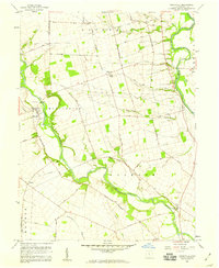
1958 Map of Darbyville
USGS Topo · Published 1959About this map
Big Darby Creek meanders deeply across the center of this 1950s Pickaway County landscape, carving a fertile valley between the townships of Muhlenberg and Jackson. The settlement of Darbyville sits along the creek's western bank, while smaller communities like Robtown, Fox, and Pherson dot the surrounding farmland. The map reveals an intricate network of local roads such as Turney-Caldwell Road and West Ford Road, which connect rural homesteads to landmarks like Scioto Chapel and the Township School.
Find a feature on this map
39 named features on this map. Tap any name to fly to it.
Don’t see what you’re looking for? This feature index may not catch every label — zoom into the map to look around manually.
Map Details
Editions of this 1958 Darbyville Map
3 editions found
Other maps of this area

1911 · Era
USGS Topo · 1:62,500

1913 · Era
USGS Topo · 1:62,500

1914 · Circleville
USGS Topo · 1:62,500

1923 · West Columbus
USGS Topo · 1:62,500

1925 · East Columbus
USGS Topo · 1:62,500

1925 · West Columbus
USGS Topo · 1:62,500

1943 · Era
USGS Topo · 1:62,500

1943 · Circleville
USGS Topo · 1:62,500

1943 · East Columbus
USGS Topo · 1:62,500

1947 · Columbus
USGS Topo · 1:250,000