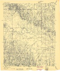
1893 Map of Darlington
USGS Topo · Published 1893About this map
Fort Reno and the adjacent Darlington (Cheyenne and Arapahoe Ind.) Agency anchor this 1893 landscape, illustrating the complex intersection of military presence and Indigenous governance in Oklahoma Territory. The North Fork Canadian River meanders through the center of the sheet, surrounded by a terrain of dramatic ridges and deeply carved creek beds like Red Rock Creek. The presence of African City in the northwest corner and the early layout of Calumet reflect the rapid settlement patterns occurring during this era of land runs and frontier expansion. Large tracts such as Cantonment Park dominate the northern portion of the map, while natural features like Red Rock Spring provided critical water sources in an era before widespread infrastructure. This survey captures a moment when colonial military outposts and tribal agencies still served as the primary administrative hubs for the surrounding prairie.
Find a feature on this map
14 named features on this map. Tap any name to fly to it.
Don’t see what you’re looking for? This feature index may not catch every label — zoom into the map to look around manually.
Map Details
Editions of this 1893 Darlington Map
2 editions found
Other maps of this area

1892 · Kingfisher
USGS Topo · 1:125,000

1893 · Fort Reno
USGS Topo · 1:62,500

1893 · Buggy Creek
USGS Topo · 1:62,500

1893 · Minco
USGS Topo · 1:62,500

1893 · Loyal
USGS Topo · 1:62,500

1895 · Kingfisher
USGS Topo · 1:125,000

1904 · Chickasha
USGS Topo · 1:125,000

1941 · Fort Reno
USGS Topo · 1:62,500

1942 · Fort Reno
USGS Topo · 1:62,500

1942 · Geary
USGS Topo · 1:62,500