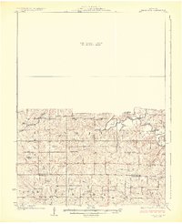
1925 Map of Darlington
USGS Topo · Published 1925About this map
The Grand River and its numerous tributaries, including Hickory Creek and Jolly Creek, carve through the rolling hills of Gentry and DeKalb counties. This mid-1920s topography highlights a deeply established rural social structure defined by one-room schoolhouses such as Rattlesnake School, Red Star School, and Limestone School. The Chicago Burlington and Quincy railroad cuts through the northwestern corner near Ford City, while small rural centers like Berlin and Winslow anchor the southern townships. Landmark crossings like Crawford Bridge and Osborne Bridge provide key transit points over the river. The presence of numerous country schools and houses of worship like Pleasant Hill Church and Mt Tabor Church offers researchers a fine-grained view of early 20th-century Missouri farm life before the consolidation of rural districts.
Find a feature on this map
41 named features on this map. Tap any name to fly to it.
Don’t see what you’re looking for? This feature index may not catch every label — zoom into the map to look around manually.
Map Details
Editions of this 1925 Darlington Map
3 editions found
Other maps of this area

1923 · Clarksdale
USGS Topo · 1:62,500

1923 · Maysville
USGS Topo · 1:62,500

1924 · Winston
USGS Topo · 1:62,500

1925 · Pattonsburg
USGS Topo · 1:62,500

1925 · Clarksdale
USGS Topo · 1:62,500

1925 · Stanberry
USGS Topo · 1:62,500

1925 · Maysville
USGS Topo · 1:62,500

1925 · Darlington
USGS Topo · 1:62,500

1939 · Stanberry
USGS Topo · 1:62,500

1940 · Parnell
USGS Topo · 1:62,500