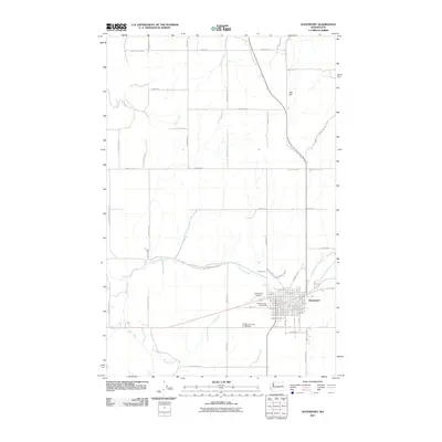
2011 Map of Davenport
USGS Topo · Published 2011About this map
Davenport serves as the focal point of this Eastern Washington landscape, anchored by the Lincoln County Fairgrounds and Davenport Airport. The settlement pattern reflects a deeply established agricultural network, where a grid of rural roads—many bearing family names like Teel Hill Rd N and Geiger Rd N—segments the wheat-growing country. Water sources are vital to this high plateau, evidenced by the convergence of Hawk Creek, Cottonwood Creek, and Bluestem Creek which drain the surrounding coulees.
Find a feature on this map
63 named features on this map. Tap any name to fly to it.
Don’t see what you’re looking for? This feature index may not catch every label — zoom into the map to look around manually.
Map Details
Editions of this 2011 Davenport Map
This is the sole edition of this map. No revisions or reprints were ever made.
Other maps of this area

1948 · Lincoln
USGS Topo · 1:62,500

1948 · Turtle Lake
USGS Topo · 1:62,500

1950 · Lincoln
USGS Topo · 1:62,500

1950 · Turtle Lake
USGS Topo · 1:62,500

1953 · Ritzville
USGS Topo · 1:250,000

1959 · Ritzville
USGS Topo · 1:250,000

1965 · Ritzville
USGS Topo · 1:250,000

1969 · Bluestem
USGS Topo · 1:24,000
1969 · Mondovi
USGS Topo · 1:24,000

1969 · Rocklyn
USGS Topo · 1:24,000