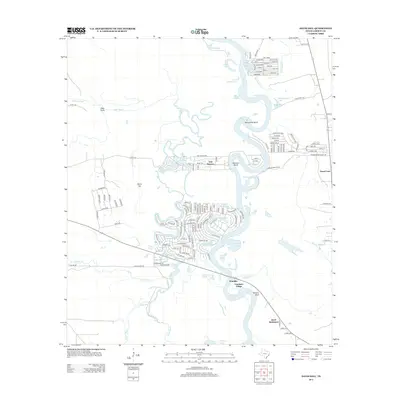
2013 Map of Davis Hill
USGS Topo · Published 2013About this map
The Trinity River dominates this portion of Liberty County, winding through a complex of oxbow lakes and bottomlands. Significant bends in the river like Sevenmile Bend and Hanners Bend have created a landscape of semi-isolated water bodies, including Hanners Bend Lake, Buzzard Roost Lake, and Horseshoe Lake. These natural features have historically dictated the placement of settlements and transport routes, with higher ground such as Davis Hill and Tanners Bluff providing stable locations for development away from the river's flood-prone banks.
Find a feature on this map
145 named features on this map. Tap any name to fly to it.
Don’t see what you’re looking for? This feature index may not catch every label — zoom into the map to look around manually.
Map Details
Editions of this 2013 Davis Hill Map
This is the sole edition of this map. No revisions or reprints were ever made.
Other maps of this area

1943 · Liberty
USGS Topo · 1:125,000

1954 · Beaumont
USGS Topo · 1:250,000

1955 · Daisetta
USGS Topo · 1:62,500

1955 · Saratoga
USGS Topo · 1:62,500

1955 · Rayburn
USGS Topo · 1:62,500

1955 · Liberty
USGS Topo · 1:62,500

1957 · Beaumont
USGS Topo · 1:250,000

1984 · Beaumont
USGS Topo · 1:250,000
1984 · Rayburn
USGS Topo · 1:24,000
1984 · Arizona Creek
USGS Topo · 1:24,000