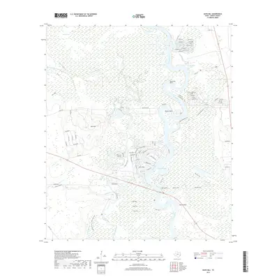
2019 Map of Davis Hill
USGS Topo · Published 2019About this map
The Trinity River snakes through this portion of Liberty County in a series of dramatic oxbows and cutoffs, creating a complex wetland environment dominated by features like Sevenmile Bend and Hanners Bend. The landscape is defined by the contrast between these low-lying fluvial features and the prominent elevation of Davis Hill to the west. This map reveals a transition from the dense sloughs and lakes of the river bottom—such as Old-River-Lake, Buzzard Roost Lake, and Jack Williams Lake—to the more structured settlements and land divisions seen at Page Tract. Local history is embedded in the naming of topographical landmarks like Tanners Bluff and the intricate network of residential roads including Coach Whip Bend and Hanna's Bend Ranch Rd, which reflect modern settlement patterns atop the ancient floodplain geology.
Find a feature on this map
99 named features on this map. Tap any name to fly to it.
Don’t see what you’re looking for? This feature index may not catch every label — zoom into the map to look around manually.
Map Details
Editions of this 2019 Davis Hill Map
This is the sole edition of this map. No revisions or reprints were ever made.
Other maps of this area

1943 · Liberty
USGS Topo · 1:125,000

1954 · Beaumont
USGS Topo · 1:250,000

1955 · Daisetta
USGS Topo · 1:62,500

1955 · Saratoga
USGS Topo · 1:62,500

1955 · Rayburn
USGS Topo · 1:62,500

1955 · Liberty
USGS Topo · 1:62,500

1957 · Beaumont
USGS Topo · 1:250,000

1984 · Beaumont
USGS Topo · 1:250,000
1984 · Rayburn
USGS Topo · 1:24,000
1984 · Arizona Creek
USGS Topo · 1:24,000