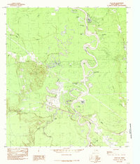
1984 Map of Davis Hill
USGS Topo · Published 1985About this map
Davis Hill rises as a prominent landmark above the intricate wetlands of Liberty County, Texas, dominating the local topography. This 1980s-era documentation highlights the meandering course of the Trinity River, where natural oxbows and bends have created an complex system of named water bodies. From the wide curve of Sevenmile Bend to the isolated waters of Jack Williams Lake and Hanners Bend Lake, the map traces a landscape shaped by fluvial processes and drainage channels like Coon Slough and Broad Slough.
Find a feature on this map
28 named features on this map. Tap any name to fly to it.
Don’t see what you’re looking for? This feature index may not catch every label — zoom into the map to look around manually.
Map Details
Editions of this 1984 Davis Hill Map
This is the sole edition of this map. No revisions or reprints were ever made.
Other maps of this area

1943 · Liberty
USGS Topo · 1:125,000

1954 · Beaumont
USGS Topo · 1:250,000

1955 · Daisetta
USGS Topo · 1:62,500

1955 · Saratoga
USGS Topo · 1:62,500

1955 · Rayburn
USGS Topo · 1:62,500

1955 · Liberty
USGS Topo · 1:62,500

1957 · Beaumont
USGS Topo · 1:250,000

1984 · Beaumont
USGS Topo · 1:250,000
1984 · Rayburn
USGS Topo · 1:24,000
1984 · Arizona Creek
USGS Topo · 1:24,000