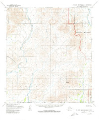
1955 Map of De Long Mountains A-2
USGS Topo · Published 1980About this map
Noatak National Monument occupies the eastern portion of this landscape, reflecting a remote wilderness before its formal designation and later revisions. The topography is defined by the drainage of the Wulik River, which snakes through the northwestern sections, fed by tributaries like Ikalukrok Creek. The terrain is punctuated by significant high points including Punupkahkroak Mountain and the central Deadlock Mountain. These landforms dictate the passage of water through the region, where Wrench Creek flows in the far northeast corner. The map also records the North Slope Borough line, marking a political division in an area otherwise characterized by its topographical isolation and lack of developed roads or settlements in the mid-20th century.
Find a feature on this map
8 named features on this map. Tap any name to fly to it.
Don’t see what you’re looking for? This feature index may not catch every label — zoom into the map to look around manually.
Map Details
Editions of this 1955 De Long Mountains A-2 Map
3 editions found
Other maps of this area

1951 · De Long Mountains
USGS Topo · 1:250,000

1951 · Noatak
USGS Topo · 1:250,000

1955 · Noatak
USGS Topo · 1:250,000

1955 · De Long Mountains
USGS Topo · 1:250,000

1955 · Noatak D-3
USGS Topo · 1:63,360

1955 · Noatak D-2
USGS Topo · 1:63,360

1955 · De Long Mountains A-3
USGS Topo · 1:63,360

1955 · De Long Mountains A-1
USGS Topo · 1:63,360

1955 · De Long Mountains A-2
USGS Topo · 1:63,360

1955 · De Long Mountains B-3
USGS Topo · 1:63,360