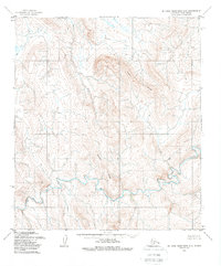
1955 Map of De Long Mountains C-5
USGS Topo · Published 1988About this map
Thetis Creek and the Ipewik River dominate this portion of the western Brooks Range, flowing through an environment defined by high-elevation divides and dramatic relief. The topography, based on aerial photographs taken in the 1950s by the Geological Survey, reveals a landscape of stark contrasts, from the braided channels of the Nilik River to the prominent heights of Thetis Ridge and Beckett Ridge. The map documents a time when the region was primarily accessible only for scientific observation and surveying, as evidenced by the lack of any man-made roads or trails. This 1955 survey provides an essential record of the pristine drainage patterns and geological formations before modern mapping technologies redefined our view of the North Slope.
Find a feature on this map
11 named features on this map. Tap any name to fly to it.
Don’t see what you’re looking for? This feature index may not catch every label — zoom into the map to look around manually.
Map Details
Editions of this 1955 De Long Mountains C-5 Map
2 editions found
Other maps of this area

1951 · De Long Mountains
USGS Topo · 1:250,000

1952 · Point Hope
USGS Topo · 1:250,000

1952 · Point Hope D-1
USGS Topo · 1:63,360

1955 · De Long Mountains
USGS Topo · 1:250,000

1955 · Point Hope
USGS Topo · 1:250,000

1955 · Point Hope C-1
USGS Topo · 1:63,360

1955 · Point Hope B-1
USGS Topo · 1:63,360

1955 · De Long Mountains D-4
USGS Topo · 1:63,360

1955 · De Long Mountains C-4
USGS Topo · 1:63,360

1955 · De Long Mountains C-5
USGS Topo · 1:63,360