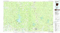
1986 Map of De Queen
USGS Topo · Published 1986About this map
Broken Bow Lake dominates the central landscape of this 1980s-era survey, highlighting the significant water resources and recreational infrastructure of the Arkansas-Oklahoma borderlands. To the west, the Glover River and Mountain Fork River carve through a heavily forested region protected by the Ouachita National Forest and the Mc Curtain County State Wilderness Area. The map documents the established community of Broken Bow and the cross-border connectivity provided by the Kansas City Southern and De Queen and Eastern railroads.
Find a feature on this map
152 named features on this map. Tap any name to fly to it.
Don’t see what you’re looking for? This feature index may not catch every label — zoom into the map to look around manually.
Map Details
Editions of this 1986 De Queen Map
2 editions found
Other maps of this area

1890 · Mount Ida
USGS Topo · 1:125,000

1890 · Poteau Mountain
USGS Topo · 1:125,000

1899 · Poteau Mountain
USGS Topo · 1:125,000

1900 · Winding Stair
USGS Topo · 1:125,000

1901 · Tuskahoma
USGS Topo · 1:125,000

1901 · Alikchi
USGS Topo · 1:125,000

1902 · Lukfata
USGS Topo · 1:125,000

1906 · Caddo Gap
USGS Topo · 1:125,000

1908 · Tuskahoma
USGS Topo · 1:125,000

1909 · Tuskahoma
USGS Topo · 1:125,000