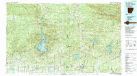
1986 Map of De Queen
USGS Topo · Published 1990About this map
Broken Bow Lake and the McCurtain County State Wilderness Area dominate the western portion of this 1980s landscape, illustrating the transition from the Boktuklo Mountains to the managed waters of the Little River watershed. The map details a region defined by its timber and water resources, spanning the border from McCurtain County, Oklahoma, into the heart of the Ouachita National Forest in Arkansas. The industrial and transportation hub of De Queen serves as a focal point, where the Kansas City Southern RR intersects with the De Queen & Eastern RR, marking the historical importance of rail in the local economy.
Find a feature on this map
102 named features on this map. Tap any name to fly to it.
Don’t see what you’re looking for? This feature index may not catch every label — zoom into the map to look around manually.
Map Details
Editions of this 1986 De Queen Map
2 editions found
Other maps of this area

1890 · Mount Ida
USGS Topo · 1:125,000

1890 · Poteau Mountain
USGS Topo · 1:125,000

1899 · Poteau Mountain
USGS Topo · 1:125,000

1900 · Winding Stair
USGS Topo · 1:125,000

1901 · Tuskahoma
USGS Topo · 1:125,000

1901 · Alikchi
USGS Topo · 1:125,000

1902 · Lukfata
USGS Topo · 1:125,000

1906 · Caddo Gap
USGS Topo · 1:125,000

1908 · Tuskahoma
USGS Topo · 1:125,000

1909 · Tuskahoma
USGS Topo · 1:125,000