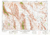
1954 Map of Death Valley
USGS Topo · Published 1972About this map
Death Valley dominates this 1954 landscape, flanked by the towering Panamint Range and Amargosa Range. This survey documents a critical era of transition in the California and Nevada desert, where early 20th-century mining history meets the modern atomic age. Remnants of the region's extraction boom are visible in settlements like Rhyolite and Ballarat, along with active sites such as the Talc City Mine and Lila C Mine.
Find a feature on this map
149 named features on this map. Tap any name to fly to it.
Don’t see what you’re looking for? This feature index may not catch every label — zoom into the map to look around manually.
Map Details
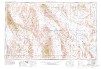
Editions of this 1954 Death Valley Map

Other maps of this area

1905 · Olancha
USGS Topo · 1:125,000

1906 · Kernville
USGS Topo · 1:125,000

1907 · Olancha
USGS Topo · 1:125,000

1907 · Mt. Whitney
USGS Topo · 1:125,000

1907 · Las Vegas
USGS Topo · 1:250,000

1908 · Kawich
USGS Topo · 1:250,000

1908 · Lida
USGS Topo · 1:250,000

1908 · Furnace Creek
USGS Topo · 1:250,000

1908 · Las Vegas
USGS Topo · 1:250,000

1908 · Kernville
USGS Topo · 1:125,000