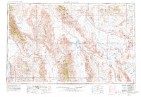
1954 Map of Death Valley
USGS Topo · Published 1980About this map
Badwater Basin -282 Lowest Elevation in the United States anchors this detailed study of the High Desert during a period of significant military and industrial presence. The landscape is defined by its extremes, from the salt flats of Owens Valley to the heights of Cerro Gordo Peak. Mining activity remains a visible part of the economy, evidenced by the Cerro Gordo Mine, Burgess Mine, and Darwin Mine.
Find a feature on this map
240 named features on this map. Tap any name to fly to it.
Don’t see what you’re looking for? This feature index may not catch every label — zoom into the map to look around manually.
Map Details
Editions of this 1954 Death Valley Map

Other maps of this area

1905 · Olancha
USGS Topo · 1:125,000

1906 · Kernville
USGS Topo · 1:125,000

1907 · Olancha
USGS Topo · 1:125,000

1907 · Mt. Whitney
USGS Topo · 1:125,000

1907 · Las Vegas
USGS Topo · 1:250,000

1908 · Kawich
USGS Topo · 1:250,000

1908 · Lida
USGS Topo · 1:250,000

1908 · Furnace Creek
USGS Topo · 1:250,000

1908 · Las Vegas
USGS Topo · 1:250,000

1908 · Kernville
USGS Topo · 1:125,000