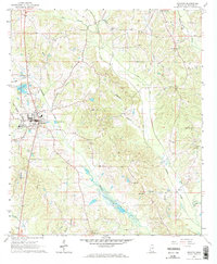
1966 Map of Decatur
USGS Topo · Published 1967About this map
Decatur serves as the focal point of this mid-1960s survey, showing the town at a moment of steady development supported by the Gulf Mobile and Ohio railroad corridor. The landscape is heavily defined by its rural institutions, with numerous country churches such as Shady Grove Ch, Little Rock Ch, and Beulah Ch serving the outlying communities. A notable concentration of education and community life is seen at the Beulah-Hubbard Sch in the northern portion of the quadrangle.
Find a feature on this map
35 named features on this map. Tap any name to fly to it.
Don’t see what you’re looking for? This feature index may not catch every label — zoom into the map to look around manually.
Map Details
Editions of this 1966 Decatur Map
2 editions found
Other maps of this area

1953 · Meridian
USGS Topo · 1:250,000

1957 · Meridian
USGS Topo · 1:250,000

1957 · Chunky
USGS Topo · 1:62,500

1962 · Post
USGS Topo · 1:24,000

1965 · Meridian
USGS Topo · 1:250,000

1966 · Hickory
USGS Topo · 1:24,000

1966 · Newton
USGS Topo · 1:24,000

1966 · Decatur NW
USGS Topo · 1:24,000

1966 · Decatur
USGS Topo · 1:24,000

1972 · Union East
USGS Topo · 1:24,000