
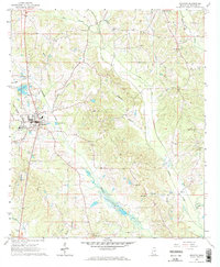
1966 Map of Decatur
USGS Topo · Published 1967About this map
The town of Decatur serves as the central hub of this mid-1960s landscape, situated where local roads converge near the Decatur Cem. This era was defined by a rural network of small congregations and community schools, such as the Beulah Hubbard Sch and churches like Shady Grove Ch and Roman Hill Ch. The Gulf Mobile and Ohio railroad cuts across the terrain, serving the local economy alongside a small Sandpit operation. Waterways like Okahatta Creek and Chunky Creek define the physical geography, winding through a patchwork of woodland and clearings. Genealogists will find particular value in the scattered family and community burial grounds, including Brand Cem and Johnson Cem, which remain as fixed points in the changing Mississippi countryside.
Find a feature on this map
34 named features on this map. Tap any name to fly to it.
Don’t see what you’re looking for? This feature index may not catch every label — zoom into the map to look around manually.
Map Details
Editions of this 1966 Decatur Map
2 editions found
Other maps of this area

1953 · Meridian
USGS Topo · 1:250,000

1957 · Meridian
USGS Topo · 1:250,000

1957 · Chunky
USGS Topo · 1:62,500

1962 · Post
USGS Topo · 1:24,000

1965 · Meridian
USGS Topo · 1:250,000

1966 · Hickory
USGS Topo · 1:24,000

1966 · Newton
USGS Topo · 1:24,000

1966 · Decatur NW
USGS Topo · 1:24,000

1972 · Union East
USGS Topo · 1:24,000
1972 · Union West
USGS Topo · 1:24,000