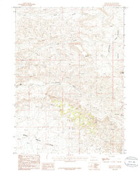
1986 Map of Deer Butte
USGS Topo · Published 1986About this map
Continental Divide bisects this high-desert landscape in Sweetwater County, marking the dramatic physical transition within the Leucite Hills. The 1980s terrain is defined by its industrial and geological features, particularly the North Baxter Basin where numerous Gas Wells and Prospects indicate active resource extraction. Prominent landmarks such as Deer Butte, Cabin Butte, and Twin Rocks provide vertical relief against a network of drainages including Cedar Canyon, Long Canyon, and Crooked Canyon. To the southeast, the geography becomes increasingly complex near Pine Ridge and Horsethief Canyon, where detailed mapping of Tailings and various Prospect sites reveals the extent of local mining and exploration efforts during this era.
Find a feature on this map
17 named features on this map. Tap any name to fly to it.
Don’t see what you’re looking for? This feature index may not catch every label — zoom into the map to look around manually.
Map Details
Editions of this 1986 Deer Butte Map
This is the sole edition of this map. No revisions or reprints were ever made.
Other maps of this area

1908 · Rock Springs
USGS Topo · 1:62,500

1910 · Rock Springs
USGS Topo · 1:62,500

1954 · Rock Springs
USGS Topo · 1:250,000

1958 · Rock Springs
USGS Topo · 1:250,000

1958 · Boars Tusk
USGS Topo · 1:62,500

1958 · Superior
USGS Topo · 1:62,500

1962 · Rock Springs
USGS Topo · 1:250,000

1968 · North Baxter
USGS Topo · 1:24,000
1968 · Reliance
USGS Topo · 1:24,000
1968 · Thayer Junction
USGS Topo · 1:24,000