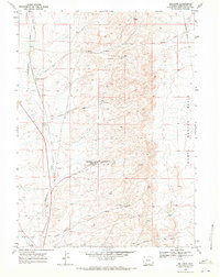
1968 Map of Reliance
USGS Topo · Published 1972About this map
Reliance and its surrounding coal-country settlements define this landscape in the late 1960s, a region deeply shaped by the mining and transport needs of the Union Pacific railroad. The map documents a complex industrial network where the Old RR Grade and several junction points, including Stansbury Junction and Winton Junction, trace the movement of resources through the high desert. Beyond the main town sites of Stansbury, Winton, and Dines, smaller landmarks such as a Racetrack and a Radio Facility appear alongside the natural drainage of Killpecker Creek. To the east, the terrain rises into the broad expanse of the North Baxter Basin, while the western portion of the sheet is marked by the presence of a Substation and a Radio Tower (KVRS), reflecting the infrastructure of mid-century Sweetwater County.
Find a feature on this map
21 named features on this map. Tap any name to fly to it.
Don’t see what you’re looking for? This feature index may not catch every label — zoom into the map to look around manually.
Map Details
Editions of this 1968 Reliance Map
This is the sole edition of this map. No revisions or reprints were ever made.
Other maps of this area

1908 · Rock Springs
USGS Topo · 1:62,500

1910 · Rock Springs
USGS Topo · 1:62,500

1954 · Rock Springs
USGS Topo · 1:250,000

1958 · Rock Springs
USGS Topo · 1:250,000

1958 · Boars Tusk
USGS Topo · 1:62,500

1961 · Pilot Butte
USGS Topo · 1:24,000

1961 · Kanda
USGS Topo · 1:24,000

1962 · Rock Springs
USGS Topo · 1:250,000

1968 · North Baxter
USGS Topo · 1:24,000
1968 · Clay Buttes SE
USGS Topo · 1:24,000