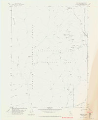
1978 Map of Dees Peak
USGS Topo · Published 1978About this map
The Salmon - Trinity Alps Primitive Area dominates this late-1970s topography, revealing a landscape defined more by former human activity than current habitation. This portion of the Klamath National Forest and Trinity National Forest preserves the sites of vanished mining camps and outposts. Researchers can trace the legacy of resource extraction through the locations of the Sherwood Mine, Hunter Mine, and Cinnabar Mine, as well as the ruins of the White Rock City (Site) and Marysville (Site). The map provides a detailed look at the rugged northern California interior, where numerous pack trails and trails connect remote points like Emmons Cabin and Milk Camp. The intricate drainage systems of New River and North Fork Eagle Creek are mapped alongside local landmarks such as Mary Blaine Mtn and Potato Mtn, offering a clear picture of the region's complex terrain and historical footprint.
Find a feature on this map
47 named features on this map. Tap any name to fly to it.
Don’t see what you’re looking for? This feature index may not catch every label — zoom into the map to look around manually.
Map Details
Editions of this 1978 Dees Peak Map
3 editions found
Other maps of this area

1909 · Big Bar
USGS Topo · 1:96,000

1915 · Big Bar and Vicinity
USGS Topo · 1:250,000

1948 · Weed
USGS Topo · 1:250,000

1950 · Weed
USGS Topo · 1:250,000

1951 · Helena
USGS Topo · 1:62,500

1951 · Ironside Mountain
USGS Topo · 1:62,500

1955 · Salmon Mtn
USGS Topo · 1:62,500

1955 · Cecilville
USGS Topo · 1:62,500

1958 · Redding
USGS Topo · 1:250,000

1958 · Weed
USGS Topo · 1:250,000