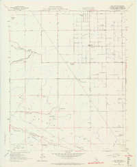
1958 Map of Del Sur
USGS Topo · Published 1964About this map
Portal Ridge dominates the southern landscape of this 1950s survey, marking the dramatic transition where the San Andreas Rift Zone carves through the terrain. The map details a rural economy defined by sprawling cattle and agricultural operations, including the Eric Munz Ranch, Cochems Ranch, and Pitchfork Ranch. Settlement is concentrated around the Del Sur area, supported by the Del Sur School and the Univ of Calif Agricultural Field Station. The geometric grid of the Antelope Valley is visible in the north, featuring the early development of Antelope Acres and the Sanatorium. This era represents a time before significant suburban expansion, where water sources like Willow Springs and the seasonal flow of Amargosa Creek were central to life. The southern edge reaches into the Angeles National Forest, where topography rises sharply toward Johnson Summit.
Find a feature on this map
41 named features on this map. Tap any name to fly to it.
Don’t see what you’re looking for? This feature index may not catch every label — zoom into the map to look around manually.
Map Details
Editions of this 1958 Del Sur Map
4 editions found
Other maps of this area

1915 · Elizabeth Lake
USGS Topo · 1:125,000

1917 · Elizabeth Lake
USGS Topo · 1:125,000

1931 · Little Buttes
USGS Topo · 1:24,000

1931 · Del Sur
USGS Topo · 1:24,000

1931 · Esperanza School
USGS Topo · 1:24,000

1932 · Lake
USGS Topo · 1:24,000

1934 · Little Buttes
USGS Topo · 1:24,000

1934 · Esperanza School
USGS Topo · 1:24,000
1936 · Del Sur
USGS Topo · 1:24,000
1937 · Lake
USGS Topo · 1:24,000