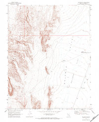
1969 Map of Delamar NW
USGS Topo · Published 1973About this map
The steep eastern escarpment of the South Pahroc Range dominates the western half of this 1969 survey, giving way to the expansive dry landscape of Delamar Valley. The region's history with water and mining is evident through specialized infrastructure, notably Cyanide Reservoir, which suggests the chemical processing once common in this gold and silver mining district. On the floor of Delamar Flat, the drainage patterns of Delamar Wash and Cedar Wash illustrate the intermittent nature of water flow in this high desert environment. Strategic water points such as Chalk Reservoir and Powerline Reservoir are positioned across the alluvial fans and valley floor, marking essential landmarks for surveyors and travelers navigating this terrain long after the primary mining booms had subsided.
Find a feature on this map
12 named features on this map. Tap any name to fly to it.
Don’t see what you’re looking for? This feature index may not catch every label — zoom into the map to look around manually.
Map Details
Editions of this 1969 Delamar NW Map
2 editions found
Other maps of this area

1885 · Pioche
USGS Topo · 1:250,000

1886 · Pioche
USGS Topo · 1:250,000

1945 · Alamo
USGS Topo · 1:125,000

1954 · Caliente
USGS Topo · 1:250,000

1959 · Caliente
USGS Topo · 1:250,000

1969 · Alamo SE
USGS Topo · 1:24,000

1969 · Delamar
USGS Topo · 1:24,000

1969 · Gregerson Basin
USGS Topo · 1:24,000

1969 · Alamo NE
USGS Topo · 1:24,000

1969 · Delamar NW
USGS Topo · 1:24,000