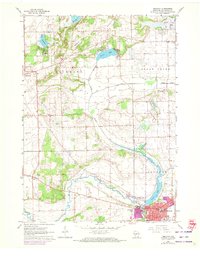
1960 Map of Delavan
USGS Topo · Published 1972About this map
Delavan and the winding Turtle Creek define this landscape as it appeared in the early 1960s, with updates reflecting local growth through 1971. The map illustrates a region transitioning between concentrated village development and the surrounding rural townships of Richmond, Sugar Creek, and Darien. In the village itself, the presence of several educational institutions, including St Andrews Sch, Christian Sch, and the local High Sch, marks the town as a local social hub.
Find a feature on this map
38 named features on this map. Tap any name to fly to it.
Don’t see what you’re looking for? This feature index may not catch every label — zoom into the map to look around manually.
Map Details
Editions of this 1960 Delavan Map
3 editions found
Other maps of this area

1891 · Koshkonong
USGS Topo · 1:62,500

1892 · Whitewater
USGS Topo · 1:62,500

1893 · Delavan
USGS Topo · 1:62,500

1893 · Whitewater
USGS Topo · 1:62,500

1893 · Shopiere
USGS Topo · 1:62,500

1894 · Koshkonong
USGS Topo · 1:62,500

1903 · Whitewater
USGS Topo · 1:62,500

1906 · Koshkonong
USGS Topo · 1:62,500

1924 · Whitewater
USGS Topo · 1:62,500

1954 · Rockford
USGS Topo · 1:250,000