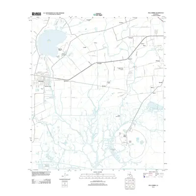
2012 Map of Delcambre
USGS Topo · Published 2012About this map
Jefferson Island and Avery Island anchor this coastal Louisiana landscape, where salt domes create significant topographic relief above the surrounding marshlands. The industrial character of the region is defined by extensive energy extraction, notably at the Jefferson Island Oil and Gas Field and the Avery Island Oil Field. These sites sit alongside long-established communities like Delcambre and Derouen, reflecting a culture deeply tied to both the land and the water. The intricate network of waterways, including Bayou Petite Anse and the Delcambre Canal, once served as the primary arteries for transit and trade. Genealogy researchers will find several family landmarks and burial sites, such as Broussard Cem and Miguel Cem, which point to the deep Acadian roots of the local population. Near the shores of Lake Peigneur, the Rip Van Winkle Gardens offer a preserved look at the region’s horticultural tradition amidst a landscape increasingly modified by industrial canals and airfields like Leonards Airfield & Tidust Park Airport.
Find a feature on this map
109 named features on this map. Tap any name to fly to it.
Don’t see what you’re looking for? This feature index may not catch every label — zoom into the map to look around manually.
Map Details
Editions of this 2012 Delcambre Map
This is the sole edition of this map. No revisions or reprints were ever made.
Other maps of this area

1932 · Abbeville SE
USGS Topo · 1:31,680

1932 · Abbeville NE
USGS Topo · 1:31,680

1937 · Derouen
USGS Topo · 1:62,500

1939 · St. Martinsville
USGS Topo · 1:62,500

1945 · New Orleans
USGS Topo · 1:250,000

1946 · Milton
USGS Topo · 1:31,680

1952 · Lake Charles
USGS Topo · 1:250,000
1954 · Milton
USGS Topo · 1:31,680

1954 · Port Arthur
USGS Topo · 1:250,000
1954 · Abbeville
USGS Topo · 1:62,500