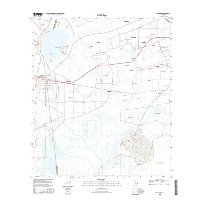
2015 Map of Delcambre
USGS Topo · Published 2015About this map
Jefferson Island and Avery Island anchor the landscape of this coastal Louisiana region, standing as salt domes that rise above the surrounding marshes and lowlands. These features are geographically distinct, with Avery Island featuring a cluster of named water bodies including Willow Pond, Hayes Pond, and Blue Pond. The mapping captures a network of small settlements such as Derouen, Brousville, and Santiague connected by rural roads and the Jefferson Canal. Near the town of Delcambre, which straddles the Vermillion Parish and Iberia Parish line, the map details local infrastructure such as the Miguel Cem and Railroad Rd. The intricate hydrology of the area is defined by numerous coulees and canals, including Hayes Coulee and Badeaux Coulee, which illustrate the complex drainage patterns essential to this low-lying territory as it was documented in the mid-2010s.
Find a feature on this map
108 named features on this map. Tap any name to fly to it.
Don’t see what you’re looking for? This feature index may not catch every label — zoom into the map to look around manually.
Map Details
Editions of this 2015 Delcambre Map
This is the sole edition of this map. No revisions or reprints were ever made.
Other maps of this area

1932 · Abbeville SE
USGS Topo · 1:31,680

1932 · Abbeville NE
USGS Topo · 1:31,680

1937 · Derouen
USGS Topo · 1:62,500

1939 · St. Martinsville
USGS Topo · 1:62,500

1945 · New Orleans
USGS Topo · 1:250,000

1946 · Milton
USGS Topo · 1:31,680

1952 · Lake Charles
USGS Topo · 1:250,000
1954 · Milton
USGS Topo · 1:31,680

1954 · Port Arthur
USGS Topo · 1:250,000
1954 · Abbeville
USGS Topo · 1:62,500