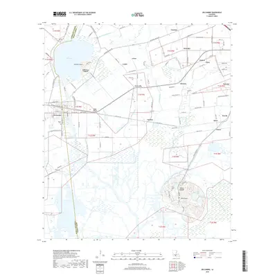
2018 Map of Delcambre
USGS Topo · Published 2018About this map
Avery Island and Jefferson Island rise as prominent geological features above the surrounding lowlands of Iberia Parish and Vermillion Parish. This 2018 survey documents a landscape defined by an intricate network of drainage and transport, including the Jefferson Canal, Delcambre Canal, and the large expanse of Lake Peigneur. The town of Delcambre sits at the western edge of the quadrangle, serving as a hub for the various agricultural and industrial hamlets such as Derouen, Brousville, and Pouffette. Local history is preserved through numerous family-named landmarks and resting places, including the Broussard Cem and Miguel Cem. The southern half of the map is dominated by the wetlands surrounding Avery Island, where specific water bodies like Blue Pond and Willow Pond are named. This era shows a coastal prairie heavily modified by water management systems like Badeaux Coulee and Norris Branch Canal to support the local economy.
Find a feature on this map
113 named features on this map. Tap any name to fly to it.
Don’t see what you’re looking for? This feature index may not catch every label — zoom into the map to look around manually.
Map Details
Editions of this 2018 Delcambre Map
This is the sole edition of this map. No revisions or reprints were ever made.
Other maps of this area

1932 · Abbeville SE
USGS Topo · 1:31,680

1932 · Abbeville NE
USGS Topo · 1:31,680

1937 · Derouen
USGS Topo · 1:62,500

1939 · St. Martinsville
USGS Topo · 1:62,500

1945 · New Orleans
USGS Topo · 1:250,000

1946 · Milton
USGS Topo · 1:31,680

1952 · Lake Charles
USGS Topo · 1:250,000
1954 · Milton
USGS Topo · 1:31,680

1954 · Port Arthur
USGS Topo · 1:250,000
1954 · Abbeville
USGS Topo · 1:62,500