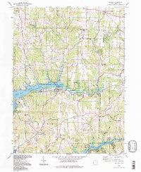
1994 Map of Dellroy
USGS Topo · Published 1998About this map
Dellroy sits at the heart of this landscape, positioned within the Muskingum Watershed Conservancy District. The terrain is defined by the significant reservoirs of Atwood Lake and Leesville Lake, which altered the local drainage of the Indian Fork and North Fork McGuire Creek. This era shows a complex mix of recreation and industry, with the Yacht Club and Atwood Lodge Airfield serving seasonal visitors while numerous Strip Mines continue to dot the surrounding hills.
Find a feature on this map
49 named features on this map. Tap any name to fly to it.
Don’t see what you’re looking for? This feature index may not catch every label — zoom into the map to look around manually.
Map Details
Editions of this 1994 Dellroy Map
This is the sole edition of this map. No revisions or reprints were ever made.
Other maps of this area

1902 · Scio
USGS Topo · 1:62,500

1904 · Scio
USGS Topo · 1:62,500

1909 · Uhrichsville
USGS Topo · 1:62,500

1910 · Carrollton
USGS Topo · 1:62,500

1911 · Uhrichsville
USGS Topo · 1:62,500

1912 · Dover
USGS Topo · 1:62,500

1912 · Carrollton
USGS Topo · 1:62,500

1944 · Dover
USGS Topo · 1:62,500

1951 · Canton
USGS Topo · 1:250,000

1953 · Canton
USGS Topo · 1:250,000