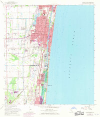
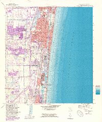
1962 Map of Delray Beach
USGS Topo · Published 1970About this map
Delray Beach and the neighboring coastal communities of the 1960s reveal a landscape in transition as residential developments like Delray Shores, Rainbow Homes, and University Park expand westward from the coastline. The map records a dense network of local schools serving these growing neighborhoods, including St Josephs Sch, Spady Sch, and Carver High Sch, alongside civic landmarks like the Waterworks and City Hall. Along the shore, the Intracoastal Waterway facilitates a maritime economy, evidenced by several yacht clubs and the developing waterfronts of Tropic Isle Harbor and Boca Harbour. Inland, the agricultural roots of the area are still visible near Yamato, while the Florida East Coast and Seaboard Coast Line railroads parallel the coast, anchoring the region's transport corridor between Boynton Beach and the northern reaches of Boca Raton.
Find a feature on this map
92 named features on this map. Tap any name to fly to it.
Don’t see what you’re looking for? This feature index may not catch every label — zoom into the map to look around manually.
Map Details
Editions of this 1962 Delray Beach Map
5 editions found
Other maps of this area

1945 · Greenacres City
USGS Topo · 1:24,000

1945 · Lake Worth
USGS Topo · 1:24,000

1946 · West Dixie Bend
USGS Topo · 1:24,000

1946 · Boca Raton
USGS Topo · 1:24,000

1947 · Delmar Farms
USGS Topo · 1:24,000

1949 · Lake Worth
USGS Topo · 1:24,000

1949 · West Dixie Bend
USGS Topo · 1:24,000

1949 · Delmar Farms
USGS Topo · 1:24,000

1950 · Boca Raton
USGS Topo · 1:24,000

1950 · Delray Beach
USGS Topo · 1:24,000