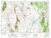
1953 Map of Delta
USGS Topo · Published 1974About this map
Dugway Proving Ground occupies a significant portion of this West-Central Utah landscape, illustrating the mid-century intersection of vast desert wilderness and military expansion. The map details a complex network of internal drainage systems, where the Sevier River flows toward its terminus at the expansive Sevier Lake. Settlement is concentrated in the eastern agricultural corridor, with towns like Delta, Hinckley, and Deseret supporting local irrigation efforts near Gunnison Bend Res. Historical landmarks are prominent, including the Pony Express Station Hist Mon and the remains of Fort Deseret, marking the 19th-century frontier history of the region. The high desert environment is further defined by the House Range and Confusion Range, while the Union Pacific railroad provides the primary industrial link between the remote valley floor and the outside world.
Find a feature on this map
83 named features on this map. Tap any name to fly to it.
Don’t see what you’re looking for? This feature index may not catch every label — zoom into the map to look around manually.
Map Details
Editions of this 1953 Delta Map
3 editions found

Other maps of this area

1885 · Salt Lake
USGS Topo · 1:250,000

1885 · Manti
USGS Topo · 1:250,000

1885 · Beaver
USGS Topo · 1:250,000

1885 · Sevier Desert
USGS Topo · 1:250,000

1885 · Fish Lake
USGS Topo · 1:250,000

1885 · Tooele Valley
USGS Topo · 1:250,000

1895 · Manti
USGS Topo · 1:250,000

1896 · Fish Lake
USGS Topo · 1:250,000

1908 · Fish Springs
USGS Topo · 1:250,000

1910 · Fish Springs
USGS Topo · 1:250,000