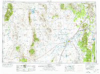
1953 Map of Delta
USGS Topo · Published 1977About this map
The Sevier River dominates this mid-century western Utah landscape, feeding agricultural hubs like Delta and Hinckley before reaching the terminal Sevier Lake. The map details the complex irrigation and water management systems necessary for survival in the Sevier Valley, including Gunnison Bend Res and Long Ridge Reservoir. To the west, the arid expanse is broken by the Deep Creek Mountains and the Fish Springs Range, where the Fish Springs National Wildlife Refuge provides a critical oasis.
Find a feature on this map
145 named features on this map. Tap any name to fly to it.
Don’t see what you’re looking for? This feature index may not catch every label — zoom into the map to look around manually.
Map Details
Editions of this 1953 Delta Map
3 editions found

Other maps of this area

1885 · Salt Lake
USGS Topo · 1:250,000

1885 · Manti
USGS Topo · 1:250,000

1885 · Beaver
USGS Topo · 1:250,000

1885 · Sevier Desert
USGS Topo · 1:250,000

1885 · Fish Lake
USGS Topo · 1:250,000

1885 · Tooele Valley
USGS Topo · 1:250,000

1895 · Manti
USGS Topo · 1:250,000

1896 · Fish Lake
USGS Topo · 1:250,000

1908 · Fish Springs
USGS Topo · 1:250,000

1910 · Fish Springs
USGS Topo · 1:250,000