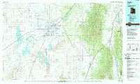
1989 Map of Delta
USGS Topo · Published 1989About this map
The irrigated basin of the Sevier River dominates this landscape, showing a network of canals and reservoirs that sustain agricultural settlements like Sugarville, Woodrow, and Abraham. In the late 1980s, the map highlights the proximity of the historic Topaz Camp northwest of Delta, providing a significant reference for researchers of World War II history. The eastern edge is defined by the steep elevation of the Fish Lake National Forest and the Pahvant Range, contrasting sharply with the broad Pahvant Valley below. Evidence of the region's volcanic past is visible at Pahvant Butte and the basalt flows of The Cinders, while the massive, often dry basin of Sevier Lake sits to the west. Transportation is anchored by the Union Pacific Railroad and Interstate 15, which connect these desert communities and managed wetlands like the Clear Lake Wildlife Management Area.
Find a feature on this map
44 named features on this map. Tap any name to fly to it.
Don’t see what you’re looking for? This feature index may not catch every label — zoom into the map to look around manually.
Map Details
Editions of this 1989 Delta Map
2 editions found
Other maps of this area

1885 · Manti
USGS Topo · 1:250,000

1885 · Beaver
USGS Topo · 1:250,000

1885 · Sevier Desert
USGS Topo · 1:250,000

1885 · Fish Lake
USGS Topo · 1:250,000

1895 · Manti
USGS Topo · 1:250,000

1896 · Fish Lake
USGS Topo · 1:250,000

1908 · Fish Springs
USGS Topo · 1:250,000

1910 · Fish Springs
USGS Topo · 1:250,000

1951 · Oak City
USGS Topo · 1:62,500

1951 · Nephi
USGS Topo · 1:62,500