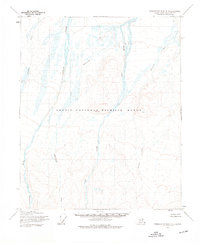
1955 Map of Demarcation Point C-5
USGS Topo · Published 1976About this map
The Arctic National Wildlife Range dominates this mid-century landscape on the North Slope, where the terrain transitions from braided river valleys to the rising foothills of the interior. The survey captures a vast, roadless expanse defined entirely by its drainage systems, most notably the wide, shifting channels of the Okpilak River and the Jago River. These glacial waterways, fed by smaller tributaries like Akubiktak River and Igilatvik Creek, illustrate the complex hydrology of the Arctic coastal plain before any significant human infrastructure was established in this quadrant. Mapped from 1955 aerial photography, the sheet records the natural state of these watersheds, including the winding course of Okpirourak Creek as it carves through the unsurveyed and unmarked lands of this northern wilderness.
Find a feature on this map
6 named features on this map. Tap any name to fly to it.
Don’t see what you’re looking for? This feature index may not catch every label — zoom into the map to look around manually.
Map Details
Editions of this 1955 Demarcation Point C-5 Map
2 editions found
Other maps of this area

1951 · Demarcation Point
USGS Topo · 1:250,000

1951 · Mt. Michelson
USGS Topo · 1:250,000

1955 · Demarcation Point
USGS Topo · 1:250,000

1955 · Mount Michelson B-1
USGS Topo · 1:63,360

1955 · Mount Michelson C-1
USGS Topo · 1:63,360

1955 · Demarcation Point C-5
USGS Topo · 1:63,360

1955 · Demarcation Point C-4
USGS Topo · 1:63,360

1955 · Mount Michelson D-1
USGS Topo · 1:63,360

1955 · Demarcation Point D-5
USGS Topo · 1:63,360

1955 · Demarcation Point D-4
USGS Topo · 1:63,360