
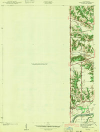
1942 Map of Dennison
USGS Topo · Published 1942About this map
The Illinois-Indiana state line bisects this 1939 survey, where the rolling bluffs of Clark and Vigo Counties meet the low-lying floodplain of the Wabash River. The settlement of South Vigo sits atop the high ground overlooking the wide bottomlands of Prairieton, a landscape defined by the serpentine curves of Chestnut Bayou and the drainage of Hawk Creek.
Find a feature on this map
22 named features on this map. Tap any name to fly to it.
Don’t see what you’re looking for? This feature index may not catch every label — zoom into the map to look around manually.
Map Details
Editions of this 1942 Dennison Map
2 editions found
Other maps of this area

1932 · Marshall
USGS Topo · 1:62,500

1937 · Marshall
USGS Topo · 1:62,500

1940 · Pimento
USGS Topo · 1:24,000

1941 · Terre Haute
USGS Topo · 1:24,000

1942 · Hutton
USGS Topo · 1:24,000

1947 · Paris
USGS Topo · 1:62,500

1948 · Terre Haute
USGS Topo · 1:24,000

1949 · Paris
USGS Topo · 1:62,500

1950 · New Goshen
USGS Topo · 1:24,000

1950 · Sandford
USGS Topo · 1:24,000