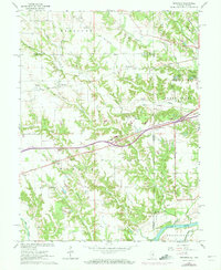
1964 Map of Dennison
USGS Topo · Published 1973About this map
The Wabash River and its meandering tributaries define this borderland landscape between Illinois and Indiana in the early 1960s. The Penn Central railroad cuts a diagonal path across the terrain, linking small trackside settlements like Dennison and McKeen with larger regional hubs. The geography is characterized by agricultural fields divided by deep creek valleys, including Sugar Creek and Crooked Creek, where early local families established their homesteads and burying grounds.
Find a feature on this map
47 named features on this map. Tap any name to fly to it.
Don’t see what you’re looking for? This feature index may not catch every label — zoom into the map to look around manually.
Map Details
Editions of this 1964 Dennison Map
3 editions found
Other maps of this area

1932 · Marshall
USGS Topo · 1:62,500

1937 · Marshall
USGS Topo · 1:62,500

1940 · Pimento
USGS Topo · 1:24,000

1941 · Terre Haute
USGS Topo · 1:24,000

1942 · Hutton
USGS Topo · 1:24,000

1942 · Dennison
USGS Topo · 1:24,000

1947 · Paris
USGS Topo · 1:62,500

1948 · Terre Haute
USGS Topo · 1:24,000

1949 · Paris
USGS Topo · 1:62,500

1950 · New Goshen
USGS Topo · 1:24,000