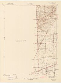
1942 Map of Denton
USGS Topo · Published 1942About this map
Denton and Cherry Hill anchor this rural landscape along the border of Washtenaw and Wayne Counties during the early 1940s. The area is defined by a dense network of agricultural drainage and small waterways, including the Lower Rouge River, Fellows Creek, and Tonquish Creek, which carve through the townships of Superior, Canton, and Plymouth. This survey captures a moment when the regional economy was transitioning from purely agrarian life toward early suburban development, evidenced by the presence of the Plymouth Hills Golf Club in the north and the steady traffic of the Michigan Central railroad to the south.
Find a feature on this map
49 named features on this map. Tap any name to fly to it.
Don’t see what you’re looking for? This feature index may not catch every label — zoom into the map to look around manually.
Map Details
Editions of this 1942 Denton Map
2 editions found
Other maps of this area

1902 · South Lyon
USGS Topo · 1:62,500

1902 · Ypsilanti
USGS Topo · 1:62,500

1904 · Ann Arbor
USGS Topo · 1:125,000

1905 · Wayne
USGS Topo · 1:62,500

1906 · Ypsilanti
USGS Topo · 1:62,500

1906 · South Lyon
USGS Topo · 1:62,500

1906 · Romulus
USGS Topo · 1:62,500

1908 · Ann Arbor
USGS Topo · 1:125,000

1912 · Wayne
USGS Topo · 1:62,500

1928 · Romulus
USGS Topo · 1:62,500
Featured Places
- Canton Township, MI
- Ypsilanti Charter Township, MI
- Van Buren Charter Township, MI
- Plymouth Charter Township, MI
- Ypsilanti, MI