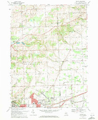
1969 Map of Denton
USGS Topo · Published 1971About this map
Ypsilanti and its northeastern expansion define the southwestern corner of this survey, where the urban grid meets the agricultural reaches of Superior and Canton townships. The landscape is a mix of developing institutional grounds and established rural landmarks, including the campus of Washtenaw Community College and the sprawling Highland Cemetery. To the east, the small settlement of Denton sits along the rail corridor, while Cherry Hill remains a distinct crossroads community.
Find a feature on this map
86 named features on this map. Tap any name to fly to it.
Don’t see what you’re looking for? This feature index may not catch every label — zoom into the map to look around manually.
Map Details
Editions of this 1969 Denton Map
4 editions found
Other maps of this area

1902 · South Lyon
USGS Topo · 1:62,500

1902 · Ypsilanti
USGS Topo · 1:62,500

1904 · Ann Arbor
USGS Topo · 1:125,000

1905 · Wayne
USGS Topo · 1:62,500

1906 · Ypsilanti
USGS Topo · 1:62,500

1906 · South Lyon
USGS Topo · 1:62,500

1906 · Romulus
USGS Topo · 1:62,500

1908 · Ann Arbor
USGS Topo · 1:125,000

1912 · Wayne
USGS Topo · 1:62,500

1928 · Romulus
USGS Topo · 1:62,500
Featured Places
- Canton Township, MI
- Ypsilanti Charter Township, MI
- Van Buren Charter Township, MI
- Plymouth Charter Township, MI
- Ypsilanti, MI