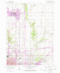
1956 Map of Des Moines NE
USGS Topo · Published 1977About this map
Ankeny stands as a primary hub of development north of the state capital, showing significant expansion near the Chicago and North Western rail line. The landscape is a transition from established agriculture, represented by the Iowa State University Experimental Farm, to the growing suburban fringe of north Des Moines. Throughout the Crocker and Douglas townships, numerous small settlements like Oralabor, Carney, and Marquisville are visible alongside local infrastructure including Saydel High Sch and Highland Memory Gardens.
Find a feature on this map
54 named features on this map. Tap any name to fly to it.
Don’t see what you’re looking for? This feature index may not catch every label — zoom into the map to look around manually.
Map Details
Editions of this 1956 Des Moines NE Map
4 editions found

Other maps of this area

1905 · Des Moines
USGS Topo · 1:62,500

1907 · Des Moines
USGS Topo · 1:62,500

1911 · Slater
USGS Topo · 1:62,500

1913 · Slater
USGS Topo · 1:62,500

1930 · Mitchellville
USGS Topo · 1:62,500

1954 · Des Moines
USGS Topo · 1:250,000

1956 · Des Moines
USGS Topo · 1:250,000

1956 · Des Moines NW
USGS Topo · 1:24,000

1956 · Des Moines SW
USGS Topo · 1:24,000

1956 · Des Moines SE
USGS Topo · 1:24,000