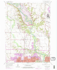
1956 Map of Des Moines NW
USGS Topo · Published 1977About this map
The Camp Dodge Military Reservation dominates the northwestern landscape of this mid-century survey, showcasing the significant military presence in the Des Moines area. This terrain is defined by the winding course of the Des Moines River and its major tributary, Beaver Creek. The map documents the suburban growth of the northern Des Moines metropolitan area, with expanding residential developments in Urbandale and Johnston beginning to press against older agricultural and institutional sites like the Iowa State University Experimental Farm. Local history is deeply embedded in the many small burial grounds such as Union Cem and McDivitt Cem that dot the townships. Transportation and recreation hubs are well-defined, including Dodge Airport, the Hyperion Country Club, and the tracks of the Chicago and North Western railroad, illustrating the diverse land use as Polk County transitioned through the 1950s and into the late 1970s.
Find a feature on this map
44 named features on this map. Tap any name to fly to it.
Don’t see what you’re looking for? This feature index may not catch every label — zoom into the map to look around manually.
Map Details
Editions of this 1956 Des Moines NW Map
5 editions found
Other maps of this area

1905 · Des Moines
USGS Topo · 1:62,500

1907 · Des Moines
USGS Topo · 1:62,500

1908 · Waukee
USGS Topo · 1:62,500

1911 · Madrid
USGS Topo · 1:62,500

1911 · Slater
USGS Topo · 1:62,500

1913 · Slater
USGS Topo · 1:62,500

1914 · Madrid
USGS Topo · 1:62,500

1954 · Des Moines
USGS Topo · 1:250,000

1956 · Des Moines
USGS Topo · 1:250,000

1956 · Des Moines NW
USGS Topo · 1:24,000