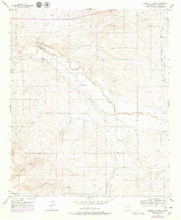
1956 Map of Diamond A Ranch
USGS Topo · Published 1979About this map
Diamond A Ranch and the White Ranch define the ranching landscape of this New Mexico territory, where water management was essential for survival and industry. The winding course of the Rio Hondo is flanked by a complex system of a ditch, levee, and an aqueduct, revealing the engineering required to sustain these remote outposts. Scattered throughout the drainage basins of Thirteenmile Draw and Rocky Arroyo are several utilitarian landmarks, including Highway Mill, Eighteenmile Mill, and Fruit Mill. These mills, along with the Center Mill, represent the infrastructure of the mid-20th-century cattle economy. The terrain is further etched by numerous intermittent watercourses like Johnson Draw and Buchanan Draw, illustrating the arid, drainage-cut character of the Chaves County landscape during this era of planetable surveying and early aerial photography.
Find a feature on this map
19 named features on this map. Tap any name to fly to it.
Don’t see what you’re looking for? This feature index may not catch every label — zoom into the map to look around manually.
Map Details
Editions of this 1956 Diamond A Ranch Map
2 editions found
Other maps of this area

1949 · Hondo Reservoir
USGS Topo · 1:24,000

1949 · Juan Lake
USGS Topo · 1:24,000

1949 · Corn Ranch
USGS Topo · 1:24,000

1950 · Corn Ranch
USGS Topo · 1:24,000

1955 · Roswell
USGS Topo · 1:250,000

1956 · Diamond A Ranch
USGS Topo · 1:24,000

1958 · Roswell
USGS Topo · 1:250,000

1959 · Diamond A Ranch
USGS Topo · 1:24,000

1961 · Indian Bluff
USGS Topo · 1:62,500

1962 · Roswell
USGS Topo · 1:250,000