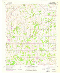
1965 Map of Dibble
USGS Topo · Published 1976About this map
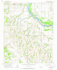
Middleberg and Dibble anchor this mid-1960s landscape along the border of McClain and Grady Counties, a region shaped by agricultural drainage and petroleum development. The terrain is defined by a dense network of waterways including Walnut Creek, Buffalo Creek, and the diverging branches of West Winter Creek and East Winter Creek. These creeks cut through a landscape dotted with numerous Gravel Pit locations and the significant North Dibble Oil Field, illustrating the area's mid-century extractive industries. Rural life is centered around local institutions such as Central Church and Dibble Church, while the presence of a Railroad Grade in the northwest suggests the evolution of transportation infrastructure. Family history researchers will find value in the clearly marked Hale Cemetery and Naples Cemetery, which provide important spatial context for local genealogies during this era of Oklahoma's history.
Find a feature on this map
26 named features on this map. Tap any name to fly to it.
Don’t see what you’re looking for? This feature index may not catch every label — zoom into the map to look around manually.
Map Details
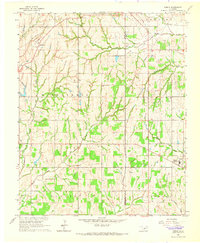
Editions of this 1965 Dibble Map
2 editions found
Other maps of this area

1902 · Rush Springs
USGS Topo · 1:125,000

1904 · Chickasha
USGS Topo · 1:125,000
1949 · Rush Springs
USGS Topo · 1:62,500
1950 · Rush Springs
USGS Topo · 1:62,500

1954 · Oklahoma City
USGS Topo · 1:250,000

1957 · Ardmore
USGS Topo · 1:250,000

1957 · Oklahoma City
USGS Topo · 1:250,000

1963 · Ardmore
USGS Topo · 1:250,000

1963 · Oklahoma City
USGS Topo · 1:250,000
1965 · Newcastle
USGS Topo · 1:24,000