
1932 Map of Dickinson
USGS Topo · Published 1932About this map
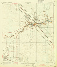
Dickinson Bayou meanders through the heart of this coastal landscape, serving as the primary drainage for the surrounding Galveston County prairies during the early 1930s. The settlement of Dickinson is a major focal point, situated at the intersection of critical transit corridors including the Houston Galveston Electric line and the G H and H RR. This era shows a community defined by its connectivity, with the Houston and Galveston Highway No 75 paralleling the rail lines toward the coast. To the southwest, the village of Arcadia sits along the Gulf Colorado and Santa Fe railroad, where the Santa Fe Sch provides a localized landmark for genealogists. The grid-like patterns of rural roads, such as Alta Loma Road and San Leon Road, illustrate the early agricultural and residential partitioning of the Texas coastal plain before the mid-century suburban expansion.
Find a feature on this map
17 named features on this map. Tap any name to fly to it.
Don’t see what you’re looking for? This feature index may not catch every label — zoom into the map to look around manually.
Map Details
Editions of this 1932 Dickinson Map
2 editions found
Other maps of this area

1916 · Genoa
USGS Topo · 1:24,000

1916 · Seabrook
USGS Topo · 1:24,000

1920 · Seabrook
USGS Topo · 1:31,680

1920 · Genoa
USGS Topo · 1:31,680

1929 · Dickinson
USGS Topo · 1:24,000

1929 · Algoa
USGS Topo · 1:24,000

1929 · Hitchcock
USGS Topo · 1:24,000

1929 · Virginia Point
USGS Topo · 1:24,000

1929 · Texas City
USGS Topo · 1:24,000

1932 · Algoa
USGS Topo · 1:31,680