
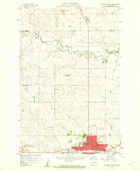
1959 Map of Dickinson North
USGS Topo · Published 1959About this map
Dickinson serves as the focal point of this Stark County landscape, shown here at a period of mid-century growth and industrial development. The map reveals a community deeply rooted in its institutions, featuring the State Teachers College and several parochial centers such as St Patricks Sch and St Wenceslaus Sch. The southern half of the sheet is dominated by the transportation and energy corridor along the Burlington Northern railroad, where an Oil Refinery and numerous Oil Well sites signify the region's resource-driven economy.
Find a feature on this map
34 named features on this map. Tap any name to fly to it.
Don’t see what you’re looking for? This feature index may not catch every label — zoom into the map to look around manually.
Map Details
Editions of this 1959 Dickinson North Map
2 editions found
Other maps of this area

1953 · Dickinson
USGS Topo · 1:250,000

1953 · Watford City
USGS Topo · 1:250,000

1957 · Dickinson
USGS Topo · 1:250,000

1957 · Watford City
USGS Topo · 1:250,000

1959 · Dickinson South
USGS Topo · 1:24,000

1959 · Lehigh
USGS Topo · 1:24,000

1962 · Davis Buttes
USGS Topo · 1:24,000

1967 · Watford City
USGS Topo · 1:250,000

1973 · Manning SE
USGS Topo · 1:24,000

1973 · New Hradec South
USGS Topo · 1:24,000