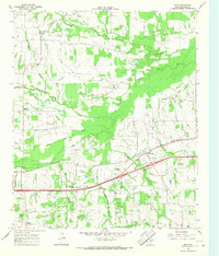
1965 Map of Dike
USGS Topo · Published 1968About this map
White Oak Creek and its many tributaries, including North Caney Creek and Richland Creek, define the landscape of this mid-1960s portion of Hopkins County. The St Louis Southwestern railroad cuts diagonally across the terrain, serving small communities like Weaver and White Oak Junction. This era shows a rural Texas economy transitioning with modern infrastructure, evidenced by a Roadside Park near the rail line and a singular Drill Hole indicating local resource exploration.
Find a feature on this map
23 named features on this map. Tap any name to fly to it.
Don’t see what you’re looking for? This feature index may not catch every label — zoom into the map to look around manually.
Map Details
Editions of this 1965 Dike Map
2 editions found
Other maps of this area

1953 · Texarkana
USGS Topo · 1:250,000

1956 · Texarkana
USGS Topo · 1:250,000

1962 · Sulphur Bluff
USGS Topo · 1:24,000

1963 · Mitchell Creek
USGS Topo · 1:24,000

1964 · Saltillo
USGS Topo · 1:24,000

1964 · Como
USGS Topo · 1:24,000

1964 · Purley
USGS Topo · 1:24,000

1964 · Sulphur Springs
USGS Topo · 1:24,000

1964 · Tira
USGS Topo · 1:24,000
1964 · Sulphur Springs SE
USGS Topo · 1:24,000