
1952 Map of Dillingham A-3
USGS Topo · Published 1962About this map
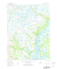
The Kvichak River dominates this southwestern Alaskan landscape, where its wide tidal flats and braided channels meet the Alagnak River at a sharp southern confluence. Along the western bank of the Kvichak, the settlement of Levelock is established near a designated Landing Strip and a prominent Tower, serving as a critical waypoint for river and air transport. The interior terrain is a dense network of countless small lakes and marshy ground, punctuated by survey markers like Vabm 313 and Vabm 223.
Find a feature on this map
19 named features on this map. Tap any name to fly to it.
Don’t see what you’re looking for? This feature index may not catch every label — zoom into the map to look around manually.
Map Details
Editions of this 1952 Dillingham A-3 Map
2 editions found
Other maps of this area

1951 · Dillingham
USGS Topo · 1:250,000

1952 · Naknek
USGS Topo · 1:250,000

1952 · Dillingham A-2
USGS Topo · 1:63,360

1952 · Dillingham A-4
USGS Topo · 1:63,360

1952 · Naknek D-3
USGS Topo · 1:63,360

1952 · Naknek D-4
USGS Topo · 1:63,360

1954 · Dillingham
USGS Topo · 1:250,000

1954 · Dillingham B-4
USGS Topo · 1:63,360
1954 · Dillingham B-2
USGS Topo · 1:63,360

1954 · Dillingham B-3
USGS Topo · 1:63,360