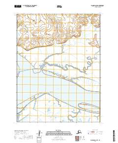
2019 Map of Dillingham A-7 SE
USGS Topo · Published 2019About this map
The confluence of the Wood River and the Nushagak River defines this landscape near Dillingham, where tidal influence and shifting waterways create a complex network of channels and sandbars. Surveyed in 2019, the map details the intricate drainage of the region, including the winding course of the Muklung River and the smaller Akomilinak Cr as they feed into the larger river systems. Geographic landmarks such as Snag Point and Picnic Point anchor the shoreline, providing reference points for navigators and local residents along the eastern bank of the Wood River. The presence of Black Slough further illustrates the low-lying, water-dominant nature of the terrain, where river activity constantly reshapes the banks and sandbars of these major Alaskan waterways.
Find a feature on this map
11 named features on this map. Tap any name to fly to it.
Don’t see what you’re looking for? This feature index may not catch every label — zoom into the map to look around manually.
Map Details
Editions of this 2019 Dillingham A-7 SE Map
This is the sole edition of this map. No revisions or reprints were ever made.
Other maps of this area

1945 · Nushagak Bay
USGS Topo · 1:250,000

1949 · Nushagak Bay
USGS Topo · 1:250,000

1951 · Dillingham
USGS Topo · 1:250,000

1951 · Nushagak Bay
USGS Topo · 1:250,000

1952 · Dillingham A-6
USGS Topo · 1:63,360

1952 · Nushagak Bay D-1
USGS Topo · 1:63,360

1952 · Dillingham A-7
USGS Topo · 1:63,360
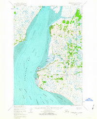
1952 · Nushagak Bay D-2
USGS Topo · 1:63,360

1954 · Dillingham
USGS Topo · 1:250,000

1964 · Nushagak Bay
USGS Topo · 1:250,000